Malawi is a landlocked country in southeastern Africa. It’s defined by its topography of highlands split by the Great Rift Valley and giant Lake Malawi. The lake’s southern end falls within Lake Malawi National Park and its clear waters are popular for diving and boating. Take a look below for 30 more fascinating and interesting facts about Malawi.
1. Its capital is Lilongwe, which is also Malawi’s biggest city. The second biggest city is Blantyre, the third is Mzuzu and the fourth is the old capital of Zomba.
2. The name Malawi comes from the Maravi, which is an old name of the Nyanja people that inhabit the area. The country is also nicknamed “The Warm Heart of Africa.”
3. Malawi is one of the smallest countries in Africa. Lake Malawi takes up about one third of the country’s area.
4. The area of Africa that’s now known as Malawi was settled by migrating Bantu groups around the 10th century. Centuries later, in 1891, the area was colonized by the British.
5. In 1953, Malawi, then known as Nyasaland, a protectorate of the United Kingdom, became a protectorate within the semi-independent Federation of Rhodesia and Nyasaland. The Federation was dissolved in 1963.
6. In 1964, the protectorate over Nyasaland was ended and Nyasaland became an independent country under Queen Elizabeth II with the new name Malawi.
7. Two years after becoming independent, Malawi became a republic.
8. When it gained independence, Malawi became a totalitarian one-party state under the presidency of Hastings Banda, who remained president until 1994, when he lost an election to Arthur Peter Mutharika, it’s current president.
9. The country has a Malawian Defense Force that includes an army, a navy and an air wing.
10. Malawi’s foreign policy is pro-Western and includes positive diplomatic relations with most countries and participation in several international organizations, including the United Nations, the Commonwealth of Nations, the Southern African Development Community, the Common Market for Eastern and Southern Africa and the African Union.
11. Malawi’s economy is heavily based in agriculture, with a largely rural population.
12. The Malawian government depends heavily on outside aid to meet development needs, although this need has decreased since 2000.
13. Since 2005, Malawi has developed several programs that focus on the country’s economy, education and healthcare.
14. There is a high prevalence of HIV/AIDS in the country, which is a big drain on the labor force and government expenditures.
15. Malawi stretches about 840 kilometers, or 520 miles, from north to south and varies in width from 8 to 160 kilometers, or 5 to 100 miles.
16. The country is endowed with amazing highlands and extensive lakes. It occupies a narrow, curving strip of land along the East African Rift Valley.
17. The Mulanje Massif, also known as Mount Mulanje, is a giant granite massif in southern Malawi. Its highest peak, Sapitwa, is the highest point in Malawi at 3,002 meters, or 9,849 feet, above sea level.
18. The network of protected areas in Malawi covers about 17% of the national territory. It’s made up of 5 national parks, 4 wildlife reserves and other types of protected areas.
19. Liwonde National Park is the most accomplished wildlife spotting and safari area in all of Malawi. It’s located along the courses of the Shire River.
20. Chongoni Rock Art Area is located in the Central Region of Malawi, consisting of 127 sites in the forested hills of the Malawi plateau with depictions of rock art and paintings of the farmer community of the Late Stone Age and the Iron Age period.
21. St. Peter’s Cathedral is the Anglican Cathedral in Likoma, the main town on Likoma Island. The cathedral is dedicated to Saint Peter, whose statue faces the lake.
22. The foundation stone for St. Peter’s Cathedral was laid by Bishop Gerard Trower on January 27, 1903, and was consecrated by Bishop Thomas Cathrew Fisher on November 14, 1911.
23. St. Michael and All Angels Church was built from 1888 to 1891 of brick at the Blantyre Mission in Blantyre. The church was designed, and its construction managed, by Rev. David Clement Scott, who had no formal architectural training.
24. The area of Africa now known as Malawi had a very small population of hunter-gatherers before waves of Bantu people began emigrating from the north around the 10th century.
25. The main agricultural products of Malawi include tobacco, sugarcane, cotton, tea, corn, potatoes, sorghum, cattle, and goats.
26. Malawi’s climate is generally tropical. A rainy season runs from November to April. There is little to no rainfall throughout much of the country from May to October.
27. Soccer is the most popular sport in Malawi, which was introduced there during British colonial rule.
28. In 2013, President Joyce Banda sold the presidential jet and a fleet of 60 luxury cars to feed the poor and grow crops to fight malnutrition.
29. In 1991, a hominid jawbone was discovered near Uraha village that was between 2.3 and 2.5 million years old, which is the oldest evidence of the genus Homo ever discovered.
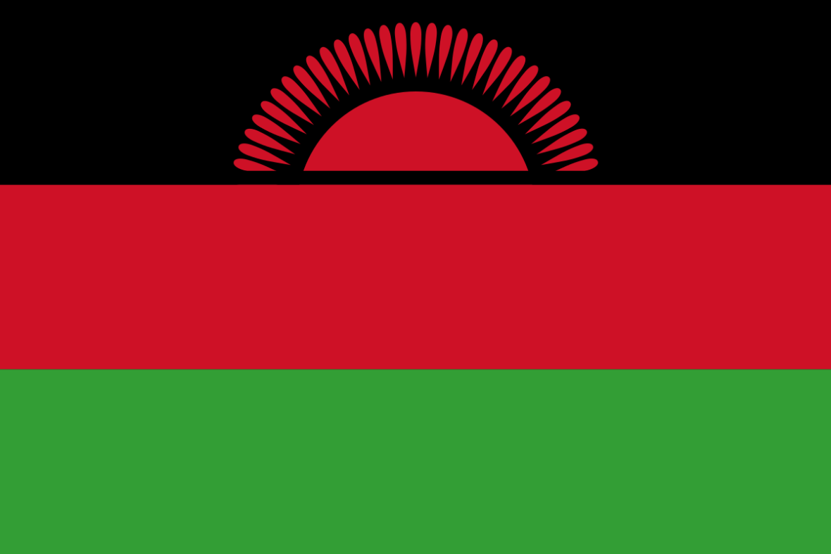
30. The Flag of Malawi is made up of three equal horizontal stripes of black, red and green with a red rising sun superimposed in the center of the black stripe. The black stripe represented the African people, the red represented the blood of the martyrs for African freedom, green represented the Malawi’s ever green nature and the rising sun represented the dawn of freedom and hope for Africa.

One Comment
kawerama
June 28, 2018 at 12:39 pmFact 8. Dr. H. Banda lost to Bakili Muluzi not Munthalika.