Twillingate is a town of 2,196 people located on the Twillingate Islands (“Toulinquet”) in Notre Dame Bay, off the north eastern shore of the island of Newfoundland in the province of Newfoundland and Labrador, Canada. The town is about 100 kilometres (62 mi) north of Lewisporte and Gander. Take a look below for 30 interesting and awesome facts bout Twillingate, Newfoundland and Labrador, Canada.
1. Incorporated on September 30, 1965, the town of Twillingate includes such localities as Back Harbour, Bayview, Durrell, Gillard’s Cove, Jenkins Cove, Manuel’s Cove, and Wild Cove.
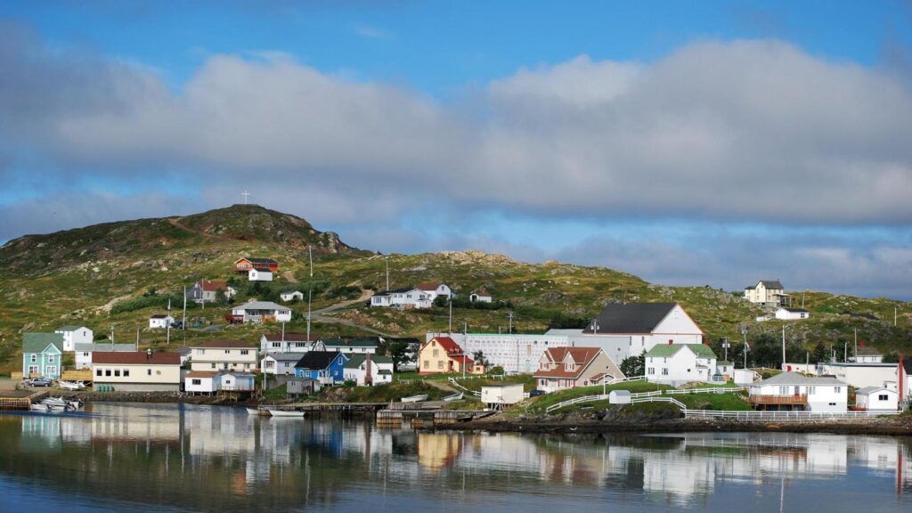
2. The Twillingate Islands provide an excellent sheltered harbour and easy access to the rich fishing grounds nearby.
3. Twillingate Island is connected to mainland Newfoundland via the Walter B. Elliott causeway as part of Route 340.
4. The town is also one of the oldest ports on the island.
5. It was a historic fishing community, but because of the decline of the fishing industry, its economy now relies more on tourism.
6. The earliest known people to inhabit the area were the Maritime Archaic, who occupied the area 3,500 years ago in 1500 BC.
7. The Maritime Archaic people were later supplanted by the Beothuk, and possibly the Dorset Inuit, who occupied the area until the arrival of European settlers.
8. The French had been fishing in the area, possibly as early as 1500, but the first European settlers did not arrive until the 17th century. The European settlers were mostly fishermen and their families from the West Country in England.
9. The native Beothuk managed to survive until the early 19th century in small numbers near Twillingate and the mouth of the Exploits River.
10. As the population grew, Twillingate became an important fishing community. It was a busy trade and service centre for Labrador and the northern shore fisheries for more than two centuries. One of the most prominent historical events that happened in the history of Twillingate was the arrival of a local newspaper – the Twillingate Sun.
11. The Twillingate Sun served the Twillingate district from 1880s until the 1950s. The Sun was a robust and professional newspaper that not only covered local and provincial news, but also international news as well.
12. Today, the Pilot, a newspaper published in Lewisporte, serves the area with its “Island’s Connection” segment. Since the Fisheries and Oceans Canada moratorium on fishing northern cod (see Endangered Species Controversies in Canada and Europe) was announced on July 2, 1992, followed shortly after by the collapse of the fishing industry, Twillingate has been forced to look to the tourist industry for income and is becoming a popular spot for visitors in the summer.
13. Twillingate is easily accessed by Route 340 from Lewisporte if approaching from western Newfoundland or by Route 330 from Gander if approaching from eastern Newfoundland. The town of Twillingate is approximately 1.5 hours from Gander and about an hour from Lewisporte.
14. Somebody driving north on Route 340 from Lewisporte or Gander to Twillingate will pass through many other small fishing communities, including Boyd’s Cove, Summerford, Virgin Arm and Newville.
15. There are several very small fishing communities that can be found on Twillingate Island before reaching the main town. The first community is Black Duck Cove and after that, a person will pass by Purcell’s Harbour and Little Harbour.
16. The western portion of the island, a series of communities now amalgamated into Bayview is accessible via Rink Road, which becomes Bayview Street shortly after it starts, in the town or by a gravel road before entering the town. These communities, in order from the Route 340-gravel road entry are Kettle Cove, Manuel’s Cove, Gillard’s Cove, Bluff Head Cove, Davis Cove and Ragged Point.
17. The town of Twillingate is about 5 km (3.1 mi) from the Twillingate-New World Island causeway. When in the town, access to the northern island is provided by “Tickle Bridge” and the communities on the southern island can be accessed via the town’s main road.
18. Route 340 runs through Twillingate as Toulinguet Street and Main Street. After turning left at the town’s main intersection (Toulinguet and Main), Route 340 runs through northern portion of the town and continues through the surrounding communities on the northern island, Back Harbour, Paradise and Wild Cove, then after a 0.5 km stretch enters the town of Crow Head and continues to the Long Point Lighthouse. If one turns right at the main intersection, that portion of Main Street (which isn’t part of Route 340) will take them through the town on the southern island, then into Durrell, ending near French Beach in Lower Jenkins’ Cove.
19. The terrain is mildly to moderately hilly even though there are no mountains near the Twillingate area. The highest point in Twillingate can be reached by the “Top of Twillingate Walking Trail”, which is located off Bayview Street.
20. Elevation varies significantly throughout the town. The main southern and northern sides of the town in addition to the neighbourhoods of Wild Cove, Back Harbour, Hart’s Cove, and portions of Bayview and Durrell are near sea level. Other parts of Durrell, Bayview and the central area of the town are situated on more elevated land. Forests can be literally be found everywhere around town.
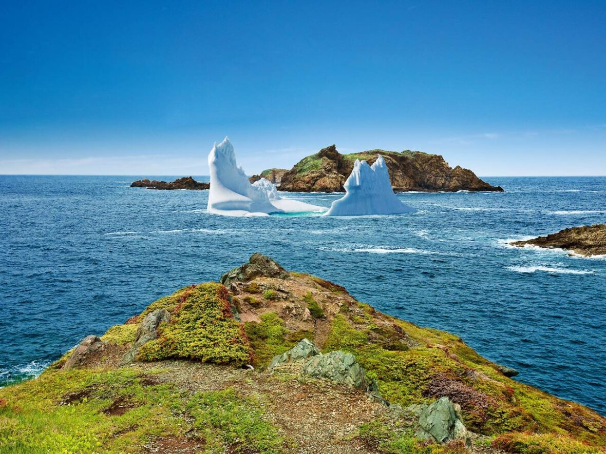
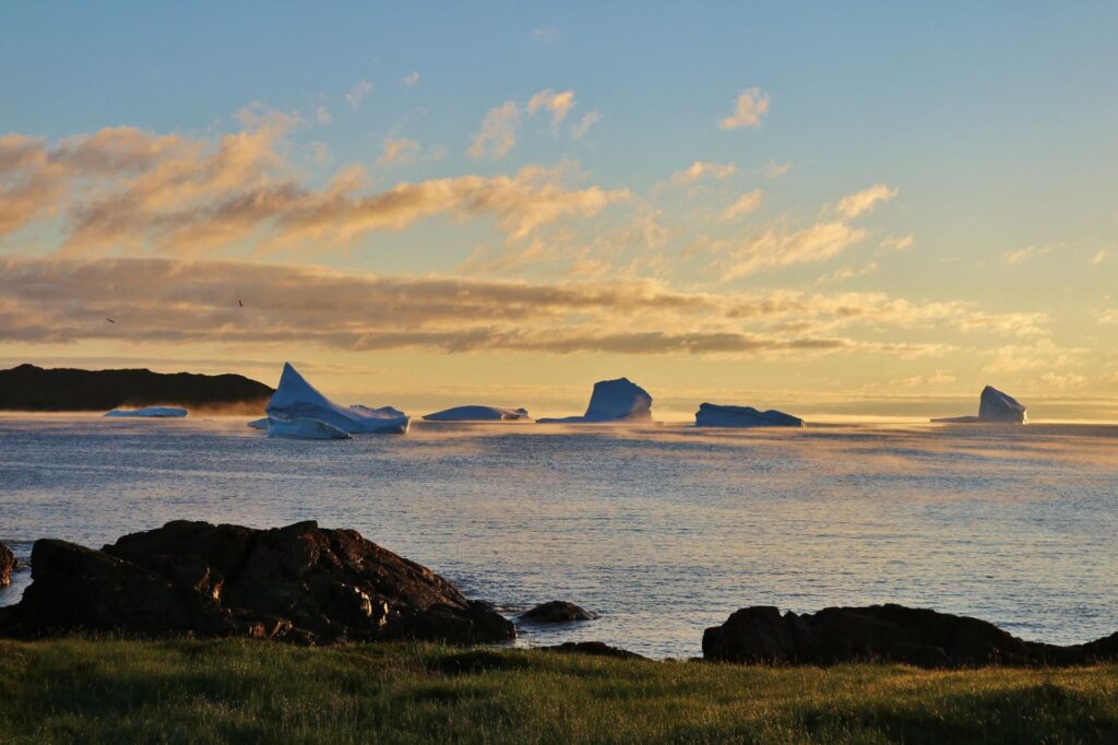
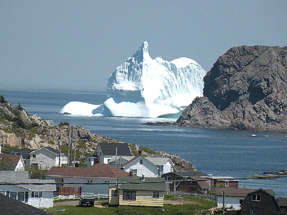
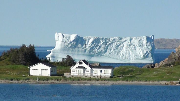
21. The region is known for its scenic, rugged coastline and its quiet and friendly atmosphere. Icebergs can be seen around the coastline in the summer months. Twillingate is part of Iceberg Alley which stretches from the coast of Labrador to the southeast coast of the island of Newfoundland. While icebergs can be found during the summer in Twillingate they are more commonly found in late May and early June.
22. Data from the Statistics Canada 2006 census show that there were 2,448 residents living in Twillingate in 2006; a change of -6.2% from 2,611 in 2001. There were a total of 1,161 private dwellings. The town’s land area is 25.74 square kilometres (9.94 sq mi) and has a population density of 95.1 inhabitants per square kilometre (246/sq mi).
23. As of the year 2006, there are 1,190 male residents and 1,255 female residents in Twillingate, with the median age of male residents at 46.6 and the median age of female residents at 48.8. The median age of the town’s population is getting older, from 38.9 at the 1996 census to 43.8 in the 2001 census and to 48.0 in 2006, compared to the province as a whole at 41.7. This aging trend can be seen across age levels with those under 55 dropping from 2,175 people in 1996 to 1,785 in 2001 and 1,520 in 2006. At the same time those 65 and older increased from 780 people in 1996 to 825 in 2001 and 920 in 2006.
24. Of the people living in Twillingate in 2006, 130 people were in a common-law relationship, 490 were single, 85 divorced, 235 were widowed, 40 separated and the majority, 1,300 were married.
25. Twillingate residents value the area’s culture and traditions. Historically, Twillingate was a prominent fishing community, but due to the decline of the fishery industry, many residents had to find employment in other industries. The area is known for its rich culture.
26. Festivities and folk music are a big part of Twillingate culture. The Fish, Fun and Folk Festival is held annually at the end of July. The festival features local talent, dances, and entertainment from Newfoundland on Thursday and Friday nights. A parade, performances from the Split Peas, and a fireworks display are held towards the end of the festival. The festival draws in many tourists from around North America and around the world and exposes them to the culture of Twillingate. Songs like “I’s the B’y”, with the chorus “Fogo, Twillingate, Moreton’s Harbour, all around the circle”, and “Lukey’s Boat”, are traditional Newfoundland songs of the region that are still sung today at cultural events.
27. In the past, mummering was done in Twillingate around Christmas, however, today, it is not practiced by as many people. A screech-in is performed annually at the Fish, Fun and Folk Festival and is also done privately elsewhere. Tourists from outside Newfoundland and Labrador are classified “Honorary Newfoundlanders” after completing a ritual that involves kissing a fish, drinking a shot of Screech and repeating lines said by the host.
28. The town hall for Twillingate is located on Main Street South, in the same building as a volunteer fire department. The current mayor of Twillingate is Gordon Noseworthy. Twillingate has historically been Liberal. The only exception to this was in 1982, when the Progressive Conservative Party won the majority of votes in the district. In 1996, Gerry Reid won an election in the Twillingate-Fogo district by 2,196 votes and in 1999, he won by 1,877 votes. In 2003, he defeated Progressive Conservative candidate Derrick Dalley, who was born in Twillingate, by 607 votes.
29. In 2007, the district voted conservative for the second time in the history of Twillingate and Derrick Dalley became the MHA for The Isles of Notre Dame electoral district. Previous members of the House of Assembly for the district include William G. Adams. The current member of Parliament for the Bonavista—Gander—Grand Falls—Windsor district is Scott Simms.
30. Medical services are provided by the small Notre Dame Bay Memorial Health Care Centre. Originally opened in 1924, it was later expanded. After its expansion, it was partially destroyed by fire. In 1976, the original 49-bed hospital was torn down and replaced by a 69-bed facility. Afterwards, due to budget measures, it was reduced to 46 beds.