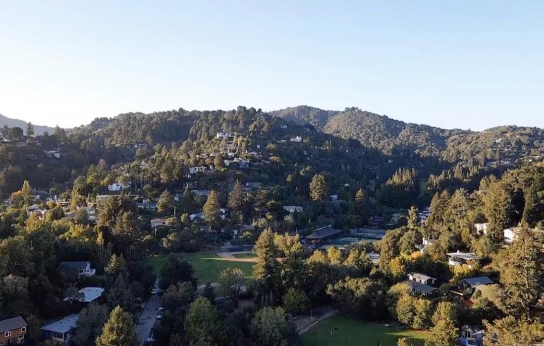
Mill Valley is a city in Marin County, California, United States, located about 14 miles (23 km) north of San Francisco via the Golden Gate Bridge and 52 miles (84 km) from Napa Valley. Take a look below for 20 amazing and interesting facts about Mill Valley, California, United States.
1. The population was 14,231 at the 2020 census.
2. Mill Valley is located on the western and northern shores of Richardson Bay, and the eastern slopes of Mount Tamalpais.
3. Beyond the flat coastal area and marshlands, it occupies narrow wooded canyons, mostly of second-growth redwoods, on the southeastern slopes of Mount Tamalpais.
4. The Mill Valley 94941 ZIP Code also includes the following adjacent unincorporated communities: Almonte, Alto, Homestead Valley, Tamalpais Valley, and Strawberry. The Muir Woods National Monument is also located just outside the city limits.
5. The first people known to inhabit Marin County, the Coast Miwok, arrived approximately 6,500 years ago. The territory of the Coast Miwok included all of Marin County, north to Bodega Bay and southern Sonoma County.
6. More than 600 village sites have been identified, including 14 sites in the Mill Valley area. Nearby archaeological discoveries include the rock carvings and grinding sites on Ring Mountain.
7. The pre-Missionization population of the Coast Miwok is estimated to be between 1,500 (Alfred L. Kroeber’s estimate for the year 1770 A.D.)[10] to 2,000 (Sherburne F. Cook’s estimate for the same year). The pre-Missionization population of the Coast Miwok may have been as high as 5,000.
8. Cook speculated that by 1848 their population had decreased to 300, and was down to 60 by 1880. As of 2011 there are over 1,000 registered members of the Federated Indians of Graton Rancheria, which includes both the Coast Miwok and the Southern Pomo, all of whom can date their ancestry back to the 14 survivors original tribal ancestors.
9. In Mill Valley, on Locust Avenue between Sycamore and Walnut Avenues, there is now a metal plaque set in the sidewalk in the area believed to be the birthplace of Chief Marin in 1871; the plaque was dedicated on May 8, 2009. The village site was first identified by Nels Nelson in 1907 and his excavation revealed tools, burials and food debris just beyond the driveway of 44 Locust Ave.
10. At that time, the mound was 20 feet (6.1 m) high. Another famous Mill Valley site was in the Manzanita area underneath the Fireside Inn (previously known as the Manzanita Roadhouse, Manzanita Hotel, Emil Plasberg’s Top Rail, and Top Rail Tavern, most of which were notorious Prohibition-era gin joints and brothels) located near the intersection of U.S. Route 101 and California State Route 1.
11. Built in 1916, the “blind pig” roadhouse was outside the dry limits of the city itself. Shell mounds have been discovered in areas by streams and along Richardson Bay, including in the Strawberry and Almonte neighborhoods.
12. Beginning with the foundation of Mission San Francisco de Asís, commonly known as Mission Dolores, in 1776, the Coast Miwok of southern Marin began to slowly enter the mission, first those from Sausalito followed by those from areas now known as Mill Valley, Belvedere, Tiburon and Bolinas.
13. They called themselves the “Huimen” people. At the mission they were taught the Catholic religion, lost their freedom, and three quarters died as a result of exposure to European diseases. As a result of the high death rate at Mission Dolores it was decided to build a new Mission San Rafael, built in 1817. Over 200 surviving Coast Miwok were taken there from Mission Dolores and Mission San Jose, including the 17 survivors of the Huimen Coast Miwok of the Richardson Bay Area. California Missions.
14. By 1834, the Mission era had ended and California was under the control of the Mexican government. They took Miwok ancestral lands, divided them and gave them to Mexican soldiers or relatives who had connections with the Mexican governor. The huge tracts of land, called ranchos by the Mexican settlers, or Californios, soon covered the area. The Miwoks who had not died or fled were often employed under a state of indentured servitude to the California land grant owners.
15. That same year, the governor of Alta California, José Figueroa, awarded to John T. Reed the first land grant in Marin, Rancho Corte Madera del Presidio. Just west of that, Rancho Saucelito was transferred to William A. Richardson in 1838 after being originally awarded to Nicolas Galindo in 1835. William Richardson also married a well-connected woman; both he and Reed were originally from Europe.
16. Richardson’s name was later applied to Richardson Bay, an arm of the San Francisco Bay that brushes up against the eastern edge of Mill Valley. The Richardson rancho contained everything south and west of the Corte Madera and Larkspur areas with the Pacific Ocean, San Francisco Bay, and Richardson Bay as the other three borders. The former encompassed what is now southern Corte Madera, the Tiburon Peninsula, and Strawberry Point.
17. In 1836, John Reed married Hilaria Sanchez, the daughter of a commandante in the San Francisco Presidio. He built the first sawmill in the county on the Cascade Creek (now Old Mill Park) in the mid-1830s on Richardson’s rancho and settled near what is now Locke Lane and LaGoma Avenue. The mill cut wood for the San Francisco Presidio. He raised cattle and horses and had a brickyard and stone quarry. Reed also did brisk businesses in hunting, skins, tallow, and other products until his death in 1843 at 38 years of age.
18. Richardson sold butter, milk and beef to San Francisco during the Gold Rush. Shortly thereafter, he made several poor investments and wound up massively in debt to many creditors. On top of losing his Mendocino County rancho, he was forced to deed the 640-acre (2.6 km2) Rancho Saucelito to his wife, Maria Antonia Martinez, daughter of the commandante of the Presidio, in order to protect her. The rest of the rancho, including the part of what is now Mill Valley that did not already belong to Reed’s heirs, was given to his administrator Samuel Reading Throckmorton. At his death in 1856 at 61 years old, Richardson was almost destitute.
19. Throckmorton came to San Francisco in 1850 as an agent for an eastern mining business before working for Richardson. As payment of a debt, Throckmorton acquired a large portion of Rancho Saucelito in 1853–54 and built his own rancho, “The Homestead,” on what is now Linden Lane and Montford Avenue. The descendants of ranch superintendent Jacob Gardner continue to be active in Marin. Some of the rest of his land was leased out for dairy farming to Portuguese settlers.
20. A majority of the immigrants came from the Azores. Those who were unsuccessful at gold mining came north to the Marin Headlands and later brought their families. In Mill Valley, Ranch “B” is one of the few remaining dairy farm buildings and is located near the parking lot at the Tennessee Valley trailhead. Throckmorton also suffered devastating financial problems before his death in 1887. His surname would later be applied to one of the major thoroughfares in Mill Valley. Richardson and Reed had never formalized the boundary lines separating their ranchos. Richardson’s heirs successfully sued Reed’s heirs in 1860 claiming the mill was built on their property. The border was officially marked as running along the Arroyo Corte Madera del Presidio along present-day Miller Avenue. Everything to the east of the creek was Reed property, and everything to the west was Richardson land. It was Richardson’s territory that would soon become part of Mill Valley when Throckmorton’s daughter Suzanna was forced to relinquish several thousand acres to the San Francisco Savings & Union Bank to satisfy a debt of $100,000 against the estate in 1889.