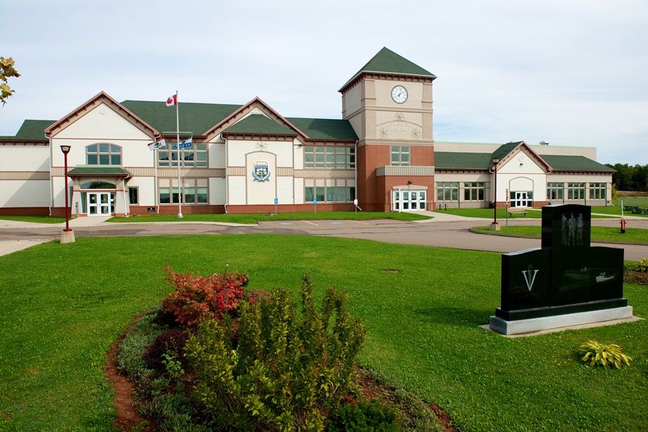
Stratford is a town located in Queens County, Prince Edward Island. Take a look below for 25 fun and amazing facts about Stratford, Prince Edward Island, Canada.
1. Situated immediately southeast of the city of Charlottetown, Stratford recorded a population of 9,706 in the 2016 census.
2. The town is the third-largest municipality in the province and has experienced population growth in recent decades since improvements were made to the Hillsborough River Bridge connecting the town with Charlottetown.
3. Southport was incorporated in 1972, with a main road named “Stratford Road,” after the secondary name that had competed with Southport as the village name more than a century earlier.
4. On April 1, 1995, the incorporated communities of Bunbury, Cross Roads, Keppoch-Kinlock, and Southport amalgamated to form the Town of Stratford.
5. At the same time, the amalgamated Stratford annexed a small portion of the Lot 48 township.
6. The legislation designated the new town as Charlottetown South but that name did not survive long and the town’s renaming became controversial as municipal leaders opted to choose a name that had no historic connection to the predecessor constituent communities.
7. It is derived from the Stratford Road, a 4 km (2.5 mi) suburban road connecting Bunbury via Southport with Cross Roads.
8. When the provincial government decided to amalgamate the communities around Southport into a town in 1995, a vote of residents on the new municipality’s name resulted in the choice of “Stratford.”
9. Stratford’s constituent communities each have had slightly different development patterns.
10. The shoreline of the Hillsborough River in Southport was historically a cottage area for city residents, with cottage development proceeding to Keppoch during the post-war era.

11. Cross Roads, Bunbury, Rosebank and Kinlock were historically agricultural communities.
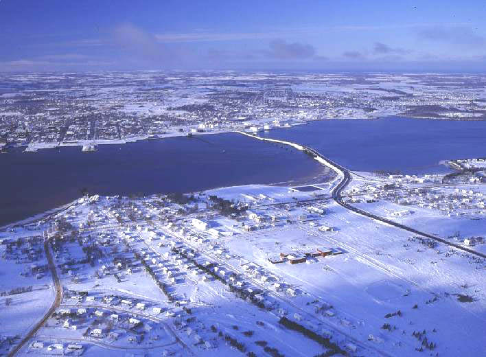
12. The town is situated on a peninsula formed by the Hillsborough River estuary, Charlottetown Harbour, and Hillsborough Bay – a sub-basin of the Northumberland Strait. It is located in the township of Lot 48.
13. Stratford’s location across the Hillsborough River from the provincial capital, Charlottetown, has made it an important gateway to the eastern part of the province throughout its history. In early times there had been Mi’kmaq summer camping areas, and during the French regime several families were recorded in the 1752 census at Anse de St-Pierre (in the area later called Keppoch).
14. Upon the confirmation of British possession of the Island by the Treaty of Paris in 1763, the Island was divided into 67 townships, called “lots.” Present-day Stratford is mostly in Lot 48, with the southern portion of the town in Lot 49.
15. The area’s fortunes, historically have been and remain tied to the evolution and development of transportation links with Charlottetown. While the area initially grew a slower pace as a farming community, its first significance was as part of the essential transportation connection between Charlottetown and the Kings County seat, Georgetown, whose port was ice-free and open for shipping more weeks of the year.

16. The Georgetown Road, built by the statute labour of local men aged 16 to 60, and male prisoners sentenced to “hard labour,” was a vital link that began at the south side of the Hillsborough River.
17. By the 1820s, a small ferry service opened to bring passengers, animals, and goods between Ferry Point in Southport to a wharf on the Charlottetown waterfront. The location across from the capital city where it landed became locally known as “the Ferry”. During the winter months, horse-drawn sleighs would operate directly across the river, if its waters were frozen.
18. As settlers arrived in the 19th century, many of them tenant farmers, land was cleared, and the constituent communities of present-day Stratford grew. Most of the early area place-names were originally the names of single farms or homes: Bellevue, Bunbury, Rosebank, Keppoch, Kinlock.
19. The locally known name for the area changed from “the Ferry” to “Southport,” referring to its proximity to Charlottetown, and Southport remained the community name until 1994. However, the name “Stratford” was proposed in the 1850s by Major J. P. Beete, a wealthy and eccentric Englishman who owned property in Lot 48. This competed with “Southport” for about 25 years until Major Beete returned to England.
20. By mid-century, the village of Southport expanded as roads were improved, and churches and schools grew along with mills, blacksmith shops, and road-houses. Several brick-makers flourished by filling the need for more substantial, fire-resistant buildings.

21. The Southport Ferry evolved from simple paddle-craft to a small steam-boat that brought people, animals and goods across the province’s major river with departures every half-hour from each side. As the appeal of summer homes grew, Keppoch and Rosebank became popular cottage areas.
22. In 1905, the Prince Edward Island Railway constructed the first Hillsborough River Bridge between Charlottetown and Southport, allowing for train travel to the eastern side of the river. Horse-drawn carriages and sleighs (and later automobiles) were also permitted on the span when trains were not operating, although it was only 1-lane wide with wood planks placed between and on each side of the rails.
23. The opening of the Hillsborough Bridge between Charlottetown and Southport in 1905 caused a decline in business around the ferry wharf. While dairy and potato farmers, market gardeners, and livestock breeders of cows, horses and silver foxes continued to flourish, during the next 50 years the number of small, mixed farms rapidly declined as the land was bought for housing developments. A two-lane highway bridge replaced the old railway bridge across the river in 1961.
24. The increased ease of automobile traffic contributed to further residential growth on the south side of the river, with permanent year-round dwellings and several subdivisions beginning to replace the seasonal cottages which fronted the Hillsborough River.
25. By the 1980s, commuter and residential development patterns in PEI were changing and it became apparent that the traffic levels on the new 2-lane Hillsborough River Bridge were surpassing its designed capacity. The 1962-era 2-lane bridge was expanded to a 4-lane bridge with new approach routes in 1995 as a sub-contract to the Northumberland Strait Crossing Project (the Confederation Bridge) with cost-sharing between the federal and provincial governments. The expanded Hillsborough River Bridge was completed in the mid-1990s at around the same time as municipal amalgamation took place.